Wednesday 27 July 2011

Further barriers on the Fallowfield Loop

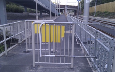
Just when you thought there were enough stupid barriers on the Fallowfield Loop, the situation gets worse...


The above photograph was taken by me on 26th June.


It now looks like this - photo from MCRcycling.


Hat-tip to MCRcycling


Just how much money was wasted on repositioning these barriers to make matters even worse for cycling? The people who did this are actively discriminating against people who through disability or choice ride non-standard cycles.

Manchester City Council and Transport for Greater Manchester are clearly failing local people who wish to use this route for cycling. Sustrans, however, should and does know better.

The Disability Discrimination Act was
enacted in 1995, but the duties on
service providers were introduced
in stages. On 1 October 2004, the
final stage came into force. The duty
on service providers reads as follows:
“Where a ‘physical feature’ makes it
impossible or unreasonably difficult for
disabled people to make use of any
service which is offered to the public,
a service provider must take reasonable
steps to:
  • Remove the feature; or
  • Alter it so that it no longer has that effect; or
  • Provide a reasonable means of avoiding the feature; or
  • Provide a reasonable alternative method of making the service available to disabled people.”


-------

One further thought - these barriers are not here to stop motorbikes or cars, they are trying to enforce the Cyclists Dismount signs at the tram crossing. Perhaps they have been moved because some people have been able to ride round the barriers...

Well there is a solution which does work and enables full acces for non standard cycles. It is in use on the Bristol to Bath Railway Path - spring loaded gates.


A tandem negotiates the gate (painted orange) on the Bristol to Bath Path.

Image from http://picasaweb.google.com/wetandem/WessexCotswolds

Thursday 21 July 2011

Cycle GM Maps 2011/12

The new online Cycle maps covering Greater Manchester turn out not to be quite as new as you might expect. Only Rochdale, Oldham and Manchester have produced updated maps this year, all the others are last year's version.

However, even the new updated map of Manchester omits one of the most useful traffic free routes along the River Irwell, as featured in this map. So even the updated maps don't feature some of the best routes, whilst showing some lines on maps that don't match the situation on the ground.


This poorly maintained pavement in Salford is marked as a "traffic-free" cycle route on these maps, despite there being no evidence of any cycle infrastructure on the ground.


The Maps

Map 1 - Wigan 2010/11

Map 2 - Bolton 2010/11

Map 3 - Bury 2010/11

Map 4 - Rochdale 2011/12

Map 5 - Oldham 2011/12

Map 6 - Tameside 2010/11

Map 7 - Stockport 2010/11

Map 8 - Manchester 2011/12

Map 9 - Trafford 2010/11

Map 10 - Salford 2010/11

Sunday 17 July 2011

Fallowfield Loop Sculptures

There are a few sculptures on the Fallowfield Loop cycle path. Unfortunately none of the leaflets give their locations or origins, so here's my record of them and any information where I can find it. Click on the images to see the locations.


Man, woman and child by local sculptor Rachel Ramchurn

More information about the project


The only Sustrans Milepost I noticed.


Four animal sculptures

from the Friends of Fallowfield Loop Newsletter

The stone sculptures situated between Princess Road and Athol Road were originally funded from a grant for the improvement of the A6 corridor, and had simply been ‘parked’ in their original site. The team has now moved them to where they belong, apart from the heaviest one which has had to be left where it is. A site has been arranged for the four animal sculptures between Slade Lane and Errwood Road, and brick and stone plinths have been constructed to give them high visibility to passers-by.


And finally the one sculpture which does feature in a leaflet, but I can find no other information about it on-line.

Tuesday 12 July 2011

Irwell River Path Map

Odd one this, a leaflet contains lots of get-off-and-walk-on-the-pavement stuff, but is the first map to show how to get round the missing bridge on the Irwell River Park route.


If you ride the route it gives views like this.


found via MOSI Facebook

Sunday 10 July 2011

Pedal MCR Opening Celebration

Pedal MCR opened for business on 9th July in the Boathouse in Platt Fields Park. It is a lovely location for a bike project and a colourful haven inside for all manner of things bike - accompanied by tasty vegan food. Congratulations to Nes, Rob & Ed and all the volunteers who've made it happen.


Nes cutting the ribbon.


The MEN taking photos in the workshop.


And tasty vegan food being eaten in the café area.

For a full list of activities visit the Pedal MCR web site.

Friday 8 July 2011

Cycle Infrastructure Design (2008)


Latest government guidance (October 2008) on doing stuff for cycling.

Shame most local authotities couldn't care less...

Saturday 2 July 2011

Cycle Barriers - who benefits?

Given the useless nature of most barriers on cycle routes, one begins to wonder who makes money out of this crap?


A closer inspection of the barriers can give a clue to the answer - the motor industry!!!


Is there any hope?